Saint Helena, Ascension and Tristan da Cunha
| Saint Helena, Ascension and Tristan da Cunha | ||||||
|---|---|---|---|---|---|---|
|
||||||
| Motto: "Loyal and Unshakeable" (St Helena) "Our faith is our strength" (Tristan da Cunha) |
||||||
| Anthem: "God Save the Queen" |
||||||
 |
||||||
| Capital | Jamestown | |||||
| Official language(s) | English | |||||
| Government | British Overseas Territory | |||||
| - | Monarch | Elizabeth II | ||||
| - | Governor of Saint Helena | Andrew Gurr | ||||
| - | Administrator of Ascension Island | Ross Denny | ||||
| - | Administrator of Tristan da Cunha | David Morley | ||||
| UK overseas territory | ||||||
| - | Annexed | 28 August 1833 | ||||
| - | Ascension added | 12 September 1922 | ||||
| - | Tristan da Cunha added | 12 January 1938 | ||||
| - | Constitution | 1 September 2009 | ||||
| Area | ||||||
| - | Total | 420 km2 162 sq mi |
||||
| Population | ||||||
| - | 2008 census | 5,661 | ||||
| Currency | Saint Helena pound (SHP) |
|||||
| Time zone | GMT (UTC+0) | |||||
| Internet TLD | .sh and .ac | |||||
| Calling code | 290 and 247 | |||||

Saint Helena, Ascension and Tristan da Cunha[1] is a British overseas territory consisting of the islands of Saint Helena, Ascension Island and the Tristan da Cunha group. It was previously known as Saint Helena and Dependencies until 1 September 2009, when a new constitution came into force giving the three islands equal status within the territory.[2]
Contents |
Administrative divisions
Administratively, the territory is divided into three areas, each governed by a council. The governor of the territory presides over the St. Helena Legislative Council, while he is represented by an administrator each on Ascension and Tristan da Cunha, presiding over the island councils of these two areas.
| Administrative Area |
Area km2 |
Area sq mi |
Population | Administrative centre | ISO code |
|---|---|---|---|---|---|
| 122 | 47 | 4,255 | Jamestown | SH | |
| 91 | 35 | 1,122 | Georgetown | AC | |
| 207 | 80 | 284 | Edinburgh of the Seven Seas | TA | |
| Total | 420 | 162 | 5,661 | Jamestown | SH |
History
Geologically each of volcanic origin, the islands of Saint Helena, Ascension Island, and Tristan da Cunha were all formerly separate colonies of the English crown, though separately discovered by several Portuguese explorers by 1502 – 1504.
The Portuguese found St. Helena uninhabited, with an abundance of trees and fresh water. They imported livestock, fruit trees and vegetables, and built a chapel and one or two houses. Though they formed no permanent settlement, the island became crucially important for the collection of food and as a rendezvous point for homebound voyages from Asia. Englishman Sir Francis Drake very probably located the island on the final lap of his circumnavigation of the world (1577–1580).[3] Further visits by other English explorers followed, and, once St Helena’s location was more widely known, English warships began to lie in wait in the area to attack Portuguese carracks on their way home from India. In developing their Far East trade, the Dutch also began to frequent the island and made a formal claim to it in 1633, but did not settle the isle and by 1651 largely abandoned it in favour of their colony at the Cape of Good Hope.
In 1657, the English East India Company was granted a charter to govern St Helena by Oliver Cromwell,[4] and the following year the Company decided to fortify and colonise the island with planters. The first governor, Captain John Dutton, arrived in 1659, and it is from this date that St Helena claims to be Britain’s second oldest (remaining) colony (after Bermuda). A fort was completed and a number of houses were built. After the restoration of the English monarchy in 1660, the East India Company received a Royal Charter giving it the sole right to fortify and colonise the island. The fort was renamed James Fort and the town Jamestown, in honour of the Duke of York and heir apparent, later King James II of England. In subsequent geopolitical developments, all the islands eventually passed to the United Kingdom as the British Empire grew into a world wide Great power. The most important and first settled, the island of St. Helena, had been governed by the East India Company since 1659. It became internationally known as the British Government's chosen place of exile of Napoleon Bonaparte, who was detained on the island from October 1815 until his death on 5 May 1821, and it was made a British crown colony on 28 August 1833. Unoccupied Ascension Island was garrisoned by the Royal Navy on 22 October 1815, shortly after which the end of the Age of Sail made its difficult location in the equatorial doldrums less important relative to its strategic importance as a centrally positioned naval coaling station. For similar reasons Tristan da Cunha was annexed as a dependency of the Cape Colony (British South Africa) on 14 August 1816 at the settlement of the Napoleonic wars.
The political union between these colonies began to take shape on 12 September 1922, when by letters patent Ascension Island became a dependency of Saint Helena. Lightly populated Tristan da Cunha, even today little more than an outpost with a population of less than three hundred, followed suit on 12 January 1938. The three island groups shared this constitutional relationship until 1 September 2009, when the dependencies were raised to equal status with St. Helena and the territory changed its name from "Saint Helena and Dependencies" to "Saint Helena, Ascension and Tristan da Cunha".
During the Battle of the Atlantic of World War II and the following several years of u-boat warfare in the Atlantic, both St. Helena and Ascension Island were used by the Allies to base patrolling anti-surface-commerce-raider and anti-submarine warfare (ASW) forces against the Axis powers' naval units. Initially long range naval patrol flying boats were used in the effort, and later in the war during the struggle to improve air coverage over the commercially important sea lanes, air strips were built to support land based aircraft which supplied, augmented and complemented the PBY Catalina patrol planes in the vitally important ASW mission.
The United States and Great Britain still jointly operate the airfield on Ascension Island, which also serves as a space-based communications, signals intelligence and navigation nexus and hub (Ground station). One of only five Global Positioning System (GPS) satellite ground stations is located there.
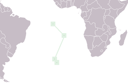
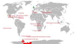
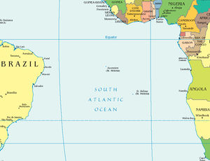 Location of Saint Helena, Ascension Island and Tristan da Cunha |
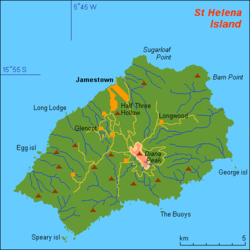 Map of St Helena |
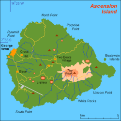 Map of Ascension Island |
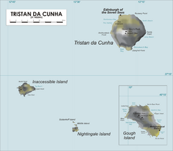 Map of Tristan da Cunha group |
References
- ↑ "The St Helena, Ascension and Tristan da Cunha Constitution Order 2009, see "EXPLANATORY NOTE"". http://www.opsi.gov.uk/si/si2009/plain/uksi_20091751_en#sch1-pt5.
- ↑ http://www.sainthelena.gov.sh/news.php/38/new-constitution
- ↑ Drake and St Helena, privately published by Robin Castell in 2005
- ↑ "History: St. Helena homepage". http://www.sthelena.se/history/cron.txt.
External links
- The Official Government Website of Saint Helena
- The Official Government Website of Ascension Island
- The Official Tristan da Cunha Website
- Saint Helena, Ascension and Tristan da Cunha entry at The World Factbook
|
|||||||||||||||||
|
||||||||||||||||||||||||
|
|||||||||||||||||||||||||||||